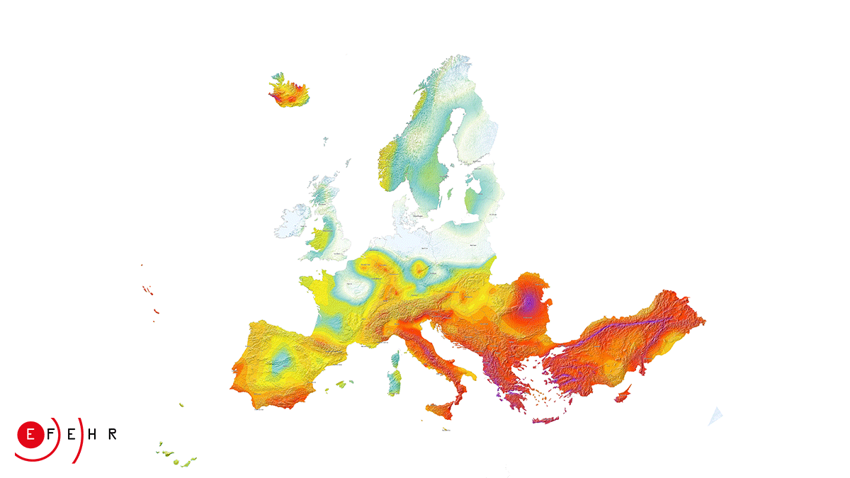
Seismic hazard
In general terms, seismic hazard defines the expected earthquake movement - caused by earthquakes - in a location, a phenomenon that may result in damage or loss.
There are currently two distinct general earthquake hazard aproaches: the deterministic method and the probabilistic method
The deterministic approach
The deterministic approach involves the development of a particular earthquake scenario (of a specified size, produced at a specified location), on the basis of which the movement of the land in the site of interest is assessed. Standard deterministic methodology consists of the following steps:
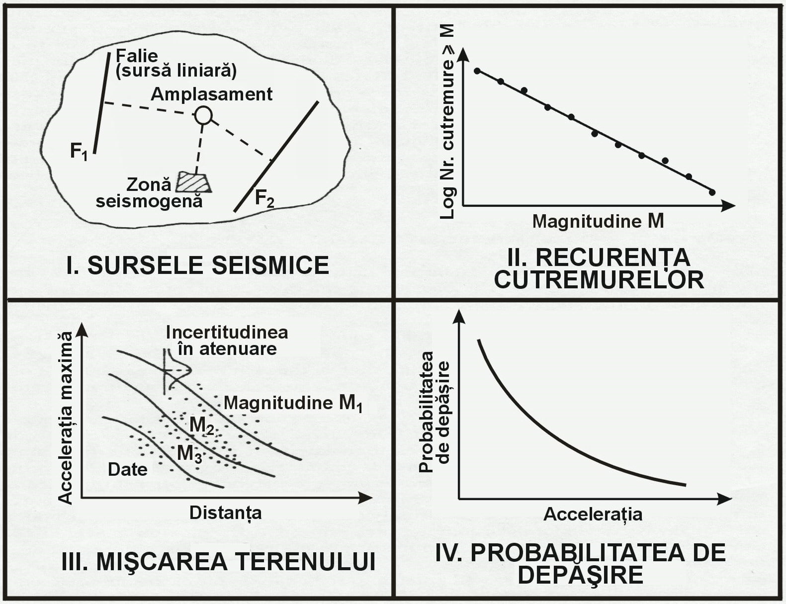
I. Identification of all sources of earthquakes that may affect the site; seismogenic sources may range from small flat faults to large seismotectonic regions. The seismic potential of each source (area) is quantified by a significant earthquake; this may be the most powerful event known historically (the most likely earthquake) or the strongest earthquake that could occur in the known tectonic (the most credible earthquake). When assessing the hazard, in the absence of additional information, the shortest distance between the seismic area and the site is considered.
II. Selection of attenuation relations to allow estimation of the seismic motion of the land in the site of interest - in terms of macroseismic intensity, maximum acceleration, amplitude of the response spectrum - as a function of magnitude of earthquakes, source distance - location and local conditions.
III. Defining the control earthquake - the quake expected to produce the highest level of land movement in the site. The selection is made by comparing, based on the mitigation relationship (set in step II), the effects produced at the site by the significant earthquakes identified in Step I (effects caused by the combination of the magnitude of the earthquake and its focal length - the minimum distance between the area seismogenesis and location). The resulting earthquake will define the seismic scenario.
IV. Determination of the parameters describing the ground movement (macroseismic intensity, maximum acceleration, amplitude of the response spectrum) corresponding to the scenario representing the most severe situation expected.
Recently an advanced neo-deterministic procedure has been proposed and developed (Panza et al., [1]), where empirical attenuation laws (step II) are substituted by numerical simulations of ground movement theoretical, generated using the available knowledge on the seismic source parameters and the propagation of the waves from source to site) and the parameters of the ground movement (steps III-IV) are extracted directly from the synthetic waveforms.
[1] Panza G.F., Romanelli F., Vaccari F., 2001. Seismic wave propagation in laterally heterogeneous anelastic media: theory and applications to the seismic zonation, Advances in Geophysics, 43, 1-95, Academic press, Elsevier.
The probabilistic approach
The probabilistic approach, proposed by Cornell's pioneering work [2], has become a widely accepted and widely used method worldwide; it determines the annual probability of overtaking - or (alternatively) the recovery period - of a certain (fixed) level of the seismic motion of the site. Probabilistic analysis provides seismic probability maps, in the form of the maximum expected land reclamation isolations (macroseismic intensity, maximum acceleration) for specified return periods. The method consists of 4 basic steps, some of which partly coincide with those of the deterministic approach:
I. Identification of seismogenic areas. This step is generally similar to the step I) of the deterministic analysis, with the difference as here, explicitly, the sources are defined as having a uniform seismic potential, the probability of producing an earthquake of a certain magnitude is the same anywhere inside source area.
II. Probabilistic characterization of seismic activity in source areas. Unlike the deterministic analysis that retains a single earthquake, or at most a maximum earthquake for each source, in the probabilistic approach each area is characterized by a probabilistic distribution of earthquakes or a recurrence relationship. This indicates the probability that a time dimension will occur anywhere within the source, within a specified time period (usually one year). For each source is also chosen a maximum earthquake. In contrast to the deterministic procedure, the maximum event is not the only earthquake considered, but the upper limit of earthquakes of all sizes, which will be analyzed for each source. Because earthquakes can occur anywhere within the seismogenic area, distances from all possible locations to locations (deterministic analysis is considered to be the closest distance from each area to the site) must be considered. Therefore, probabilistic analysis considers a range of pairs: earthquake size - site spacing and probability of occurrence associated with these pairs.
III. Selection of attenuation relations. This step to estimate the effect of earthquakes is similar to step II) of the deterministic procedure, with the difference that in the probabilistic analysis, the magnitude domain considered for earthquakes involves a family of attenuations or curves of the ground movement; each of these links a land movement parameter (macroseismic intensity, maximum acceleration) of distance for a given earthquake size.
IV. Integration across the entire magnitude and distance range for each seismogenic source to obtain - in a particular location - the probability hazard values in the form of a cumulative distribution of the terrain motion parameters. The effects of all earthquakes, of different sizes, produced from different locations in different seismogenic areas and with different probabilities of occurrence, are integrated into a single curve, which expresses the probability of overtaking within a specified time period (usually one year) ie the period of return - of certain values of the seismic motion parameters in the site (macroseismic intensity, maximum acceleration).
[2] Cornell C. A., 1968. Engineering seismic risk analysis, Bull. Seism. Soc. Am., 58, 1583-1606.
The deterministic approach vs probabilistic approach
By comparing the two seismic hazard assessment methodologies, we note that the deterministic approach is more intuitive; it involves producing a well-defined earthquake (in terms of magnitude and source distance - location), used later in the successive steps of the analysis.
The results of deterministic analysis (macroseismic intensity, maximum acceleration, amplitude of the response spectrum) are of particular practical importance, as they can be used directly in engineering applications.
However, this approach does not provide information on the occurrence of the worst-case scenario in time, in other words, it does not indicate the likelihood of the earthquake occurring during the lifetime of site structures.
In probabilistic analysis, the estimated hazard incorporates the effects of all earthquakes considered capable of affecting a particular site, and several mitigation models may be used, each with its uncertainty; Also, probabilities of producing events of different sizes are included in the analysis. Probabilistic hazard maps are generally built on a regional basis for a single "reference" class of land conditions (eg rock); therefore, in order to take into account local effects, the estimated ground movement values must be multiplied subsequently with frequency dependent factors, depending on the particular conditions in a given location.
Both methodologies - deterministic and probabilistic - play a role in seismic hazard analyzes, the two methodologies can complement each other, providing additional issues in solving the hazard problems.
One method may take precedence over the other, depending on the more or less quantitative nature of the decision to be made, but also the seismic framework or the purpose of the project (a single site or region).
Estimating the probabilistic seismic hazard (taking into account event recurrence) is important for developing viable insurance policies and increasing earthquake preparedness by planning appropriate action to mitigate their effects.
But when it comes to the cultural heritage - for which the consequences of the destruction are unacceptable - or to the critical structures (nuclear power plants, chemical plants, deposits of pollutants and radioactive waste, etc.) - whose damages, following a strong earthquake, would represent a major risk to the natural and anthropic environment - the deterministic approach based on the maximum expected seismic input becomes relevant.
The lessons of destructive earthquakes produced in the world over the last decade have highlighted the fact that events with a low rate of emergence should be treated with special attention (recent examples are the L'Aquila earthquakes, Italy, 2009, Tohoku, Japan, 2011) and as a single map of seismic hazard can not meet the requirements of all end-users.
In many situations, a recursive analysis, in which deterministic interpretations are triggered by probable outcomes and vice versa, can lead to the most realistic evaluations, and to make the most informed decisions.
The results of the hazard analysis can be convoluted with a seismic fragility function - which quantifies the expected level of construction destruction, infrastructure, etc., as a function of the level of the ground movement - to obtain a seismic risk analysis, indicating the estimated damage and loss.
Consequently, hazard analysis is a fundamental input in risk assessment.
Estimation of seismic hazard on Romanian territory
On the territory of Romania, the level of seismic hazard is determined by the presence of several destructive potential seismogenic areas. The most important, both in terms of seismic energy released and the area of destruction caused, is the major earthquake source of intermediate depth (60-200 km), located at the curvature of the Eastern Carpathians - Vrancea region. Besides this, there are several surface areas (depths <60 km), of local importance: the Fagaras - Campulung area, in the eastern part of the Southern Carpathians; the Danubian, Banat and Crisana - Maramures areas, situated in the southwest, west and northwest of Romania respectively; the Vrancea crust depth zone; the Barlad depression and the Preobrogeana depression, located in eastern Romania; the Intramoesica fault, in the southeast; the depression of Transylvania, in the central part of the territory. The extreme south-east of the country is also exposed to the effects of the Shabla seismic area, which generates strong earthquakes in northeastern Bulgaria. Descriptions of the seismogenic zones on the territory of Romania - limits, seismotectonic characteristics - can be found on the page "Seismicity of Romania".
The estimation of seismic hazard on the Romanian territory is the subject of a series of scientific papers, published in international reputable specialist magazines.
The studies were conducted both by non-deterministic approach and by probabilistic approaches (most). Probabilistic analyzes are based on methodologies that differ to a certain extent from the standard procedure (although incorporating the fundamental principles of the classical approach [2]); input data considered - earthquake catalogs, seismic zoning - as well as the parameter chosen to describe the land movement - macroseismic intensity, peak (peak) acceleration - also differ from one author (group of authors) to another. However, the results of the analyzes are consistent with each other, presenting a notable concordance.
Seismic hazard analyzes on a regional scale, for the territory of Romania
Radulian M., Vaccari F., Mandrescu N., Panza G. F., Moldoveanu C., 2000. Seismic hazard of Romania: A deterministic approach, Pure Appl. Geophys., 157, 221-247.
Musson R. M. W., 2000. Generalised seismic hazard maps for the Pannonian Basin using probabilistic methods, Pure Appl. Geophys., 157, 147-169.
Mantyniemi P., Marza V. I., Kijko A., Retief P., 2003. A new probabilistic seismic hazard analysis for the Vrancea (Romania) seismogenic zone, Nat. Haz., 29, 371-385.
Enescu D., Marmureanu A., Enescu B.D., 2004. A procedure for assessing seismic hazard generated by Vrancea earthquakes and its application. II. Atenuation curves, Romanian Reports in Physics, 56 (1), 147-159.
Ardeleanu L., Leydecker G., Bonjer K. P., Busche H., Kaiser D., Schmitt T., 2005. Probabilistic seismic hazard map for Romania as a basis for a new building code, Nat. Haz. Earth Syst. Sci., 5, 679-684.
Enescu D., Enescu B.D., 2007. A procedure for assessing seismic hazard generated by Vrancea earthquakes and its application. iii. A method for developing isoseismal and isoacceleration maps, Romanian Reports in Physics, Vol. 59 (1), 121-145.
Moldovan I.A., Popescu E., Constantin A., 2008. Probabilistic seismic hazard assessment in Romania: application for crustal seismic active zones, Rom. Journ. Phys., 53 (3-4), 575-591.
Leydecker G., Busche H., Bonjer K. P., Schmitt T., Kaiser D, Simeonova S., Solakov D., Ardeleanu L., 2008. Seismic hazard maps for Bulgaria and Romania, Nat. Haz. Earth Syst. Sci., 8, 1431-1439.
Sokolov V. Yu., Wenzel F. si Mohindra R., 2009. Probabilistic seismic hazard assessment for Romania and sensitivity analysis: A case of joint consideration of intermediate-depth (Vrancea) and shallow (crustal) seismicity, Soil Dyn. Earthquake Eng., 29, 364-381.
Marmureanu G., Cioflan C.O., Marmureanu A., 2011. Intensity seismic hazard map of Romania by probabilistic and (neo)deterministic approaches, linear and nonlinear analyses, Romanian Reports in Physics, 63 (1), 226-239.
More scientific papers (with authors activating within the NIEP), following various aspects of the estimation of seismic hazard on Romanian territory, can be found on the page PUBLICATIONS.