What is an earthquake?
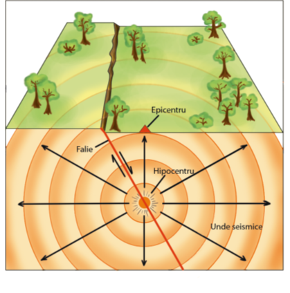
Earthquakes are natural phenomena caused by the release of energy inside the Earth after the fracture of the rocks subjected to the accumulated tensions. The surface along which the rocks "break" and travel is called a plan of failure. Earthquakes in Romania of tectonic origin occur along crust failures (located at depths of < 60 km) or at intermediate depths (approximately 60 to 200 km deep).
The magnitude (M) of an earthquake is a dimensionless dimension that characterizes the energy released in the focus of an earthquake as seismic waves It is usually determined on the Richter scale using the records of different seismic stations. Another practice is calculating the magnitude of the seismic moment, proportional to the product between the area of the breaking surface and the mean displacement on the fault. The magnitude scale is exponential: a unit-size increase of magnitude corresponds to a 30-fold increase in released energy. For example, for an earthquake of magnitude 6.0, the released energy is about 30 times greater than a magnitude earthquake of 5.0, while at an earthquake of magnitude 7.0 the released energy is about 900 times (30 x 30) bigger than at an earthquake of magnitude 5.0.
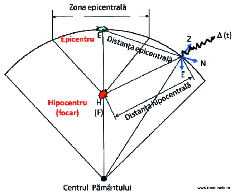
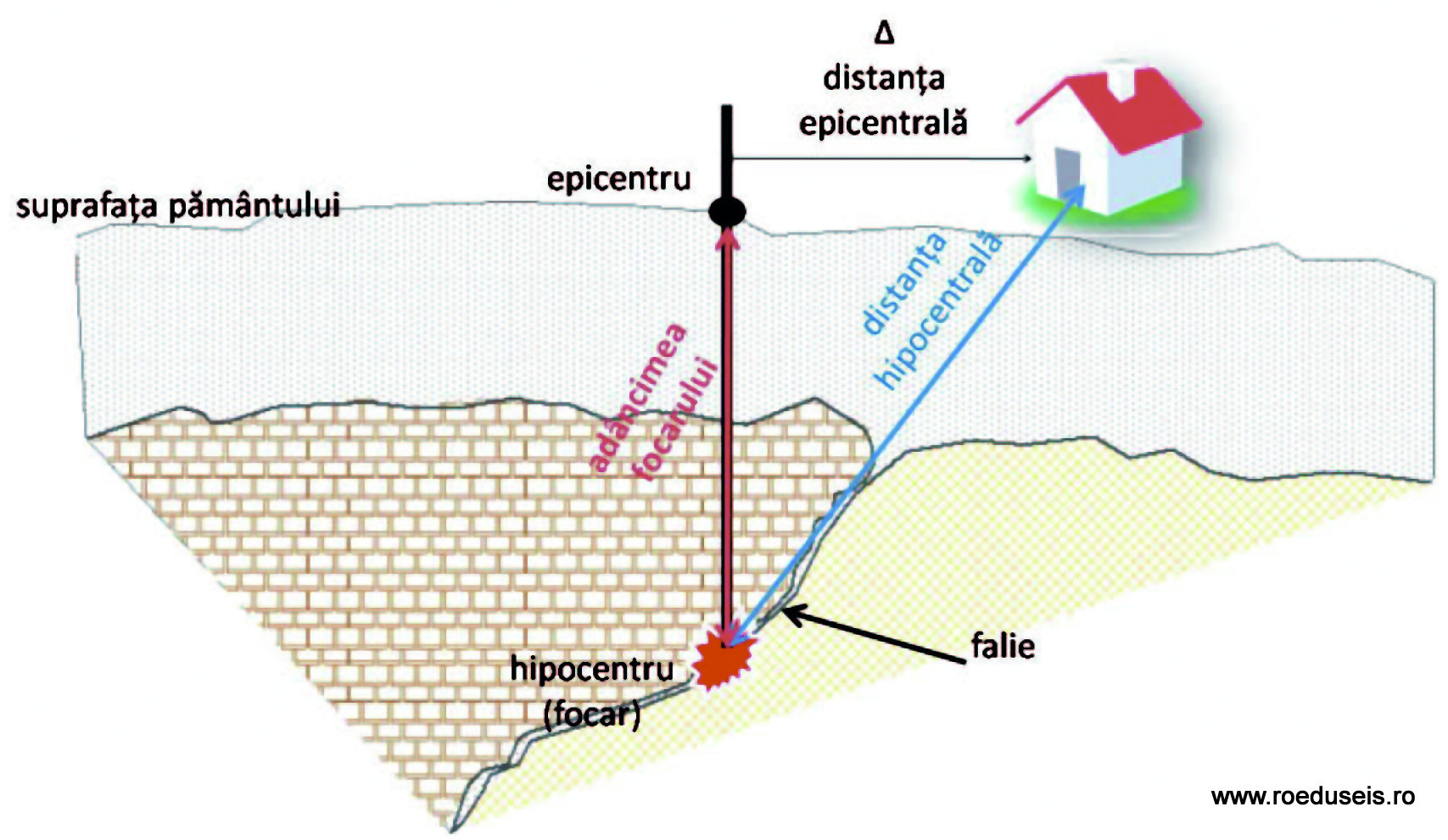
The place inside the Earth where the earthquake is generated is called a hippocampus or outbreak, and its projection at the surface of the Earth is called epicenter. The distance from the epicenter to another point on the Earth's surface is called epicentral distance, and the distance from the outbreak to a point on the surface of the Earth is called the hypocentral distance.
The effects of the earthquake

The amplitude of ground movement due to an earthquake depends on a number of factors such as magnitude, epicentral distance, hypocentral distance, topography and local geological conditions.
The Intensity (I) earthquake is the magnitude that expresses how an earthquake was felt in an area. The modified MSK (Medvedev, Sponhauer, Karnik) ladder is a 12-degree scale (I-XII) that can measure the intensity of earthquakes in different areas depending on the effects of earthquakes on humans, animals, construction, and so on.
What are the causes of earthquakes?
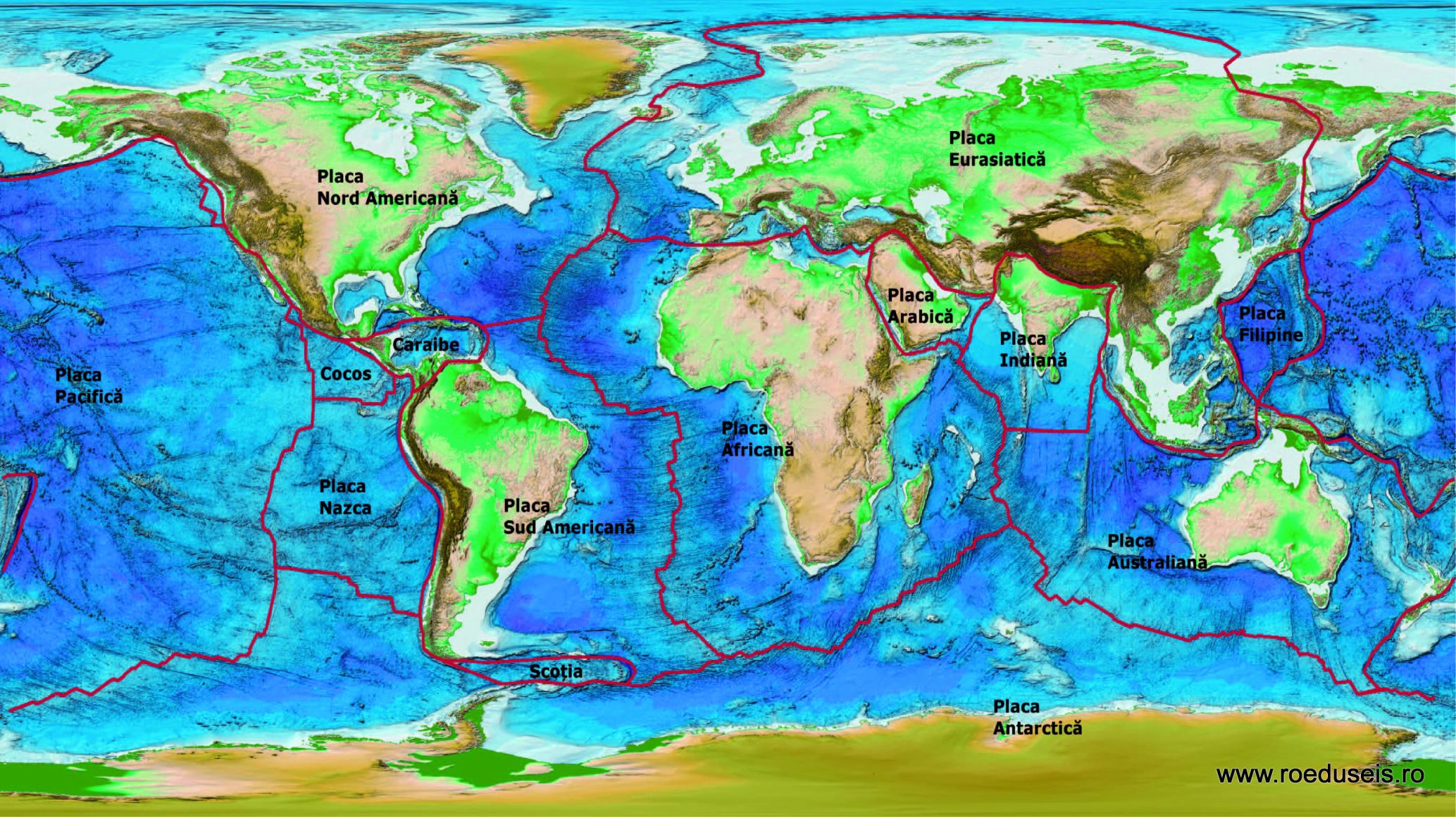
The tectonic plates. A lithospheric plate is a massive solid rock fragment with an irregular shape, made up of oceanic and continental crust. The length of the tiles can vary greatly, from a few hundred kilometers to thousands of kilometers (among the largest being the Pacific and Antarctic plates). The plates vary widely in thickness, from 15 km (young ocean lithosphere plates) up to 200 km or even more (continental continental lithospheric plates, e.g. the central areas of North and South America plates). The main force that has shaped the surface of the Earth since its formation until today is the force that has led to the fragmentation and displacement of the lithospheric plates that make up the outer shell of the Earth. Most earthquakes are due to the relative movements of the Earth's lithospheric plates and are predominantly produced at the boundaries of separation between them (plate edges). Experts identified a number of seven to 12 major plates and a larger number of underplates. The plates have been named after the continents (eg the Eurasian plate), the oceans (Pacific Plate) or the geographical regions (Arabic Plate) that they encompass.
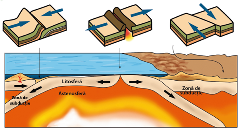
Along with earthquakes, the most obvious testimonials of the relative plate movement are the characteristic relief forms created at the edges of the plates. These differ depending on the type of relative movement of the plates relative to each other and their composition. Thus, three types of plate edges have been identified:
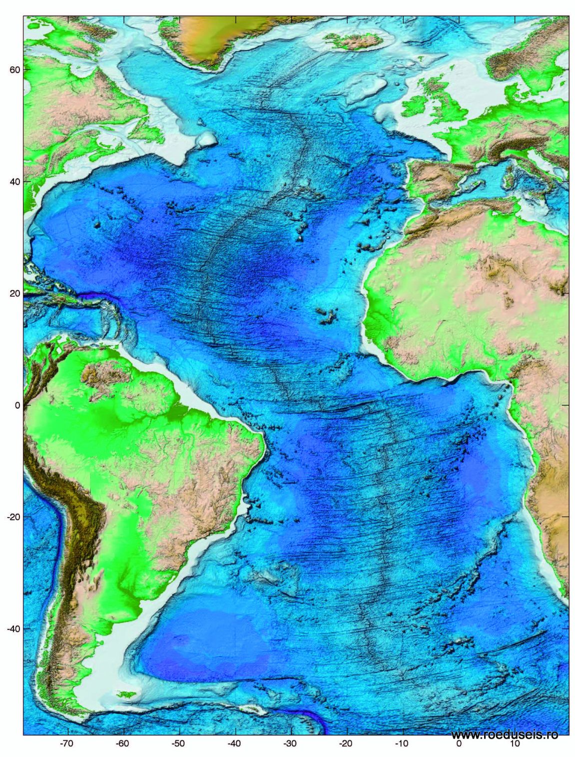
Divergent boundaries - which characterizes the interaction between two plates that move away from each other. As a result of this movement a crust opening (mid-oceanic rift) is formed through which the molten material from the astenosphere rises to the surface, cooling, forming the new ocean crust. It is deposited on both sides of the rift forming oceanic (dorsal) oceanic chains. An eloquent example is the Medio-Atlantic Rift that crosses the Arctic Ocean to southern Africa.
Convergent boundaries - where two plates collide. If, due to the diverging movement, the new crust forms, the convergence movement recycles it. The testimony of these processes is that the dimensions of Earth have remained unchanged since its formation until today.
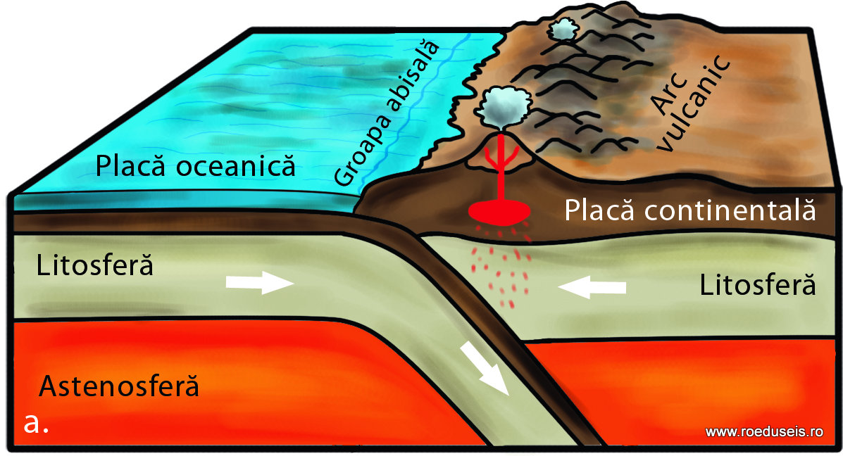
Convergence between an ocean plate and a continental one
It is one of the most common situations and leads to the formation of continental volcanic springs. Convergence between an ocean plate and a continental one. b. The Nazca Plate subduction under the South American Plateau's continental part along the Peru-Chile fossa gave birth to the Andes chain. Associated phenomena: strong earthquakes (M = 8.3, 1994 Bolivia, H = 636 km deep), active volcanoes ("Pacific Ring of Fire")
Convergence between two continental plates
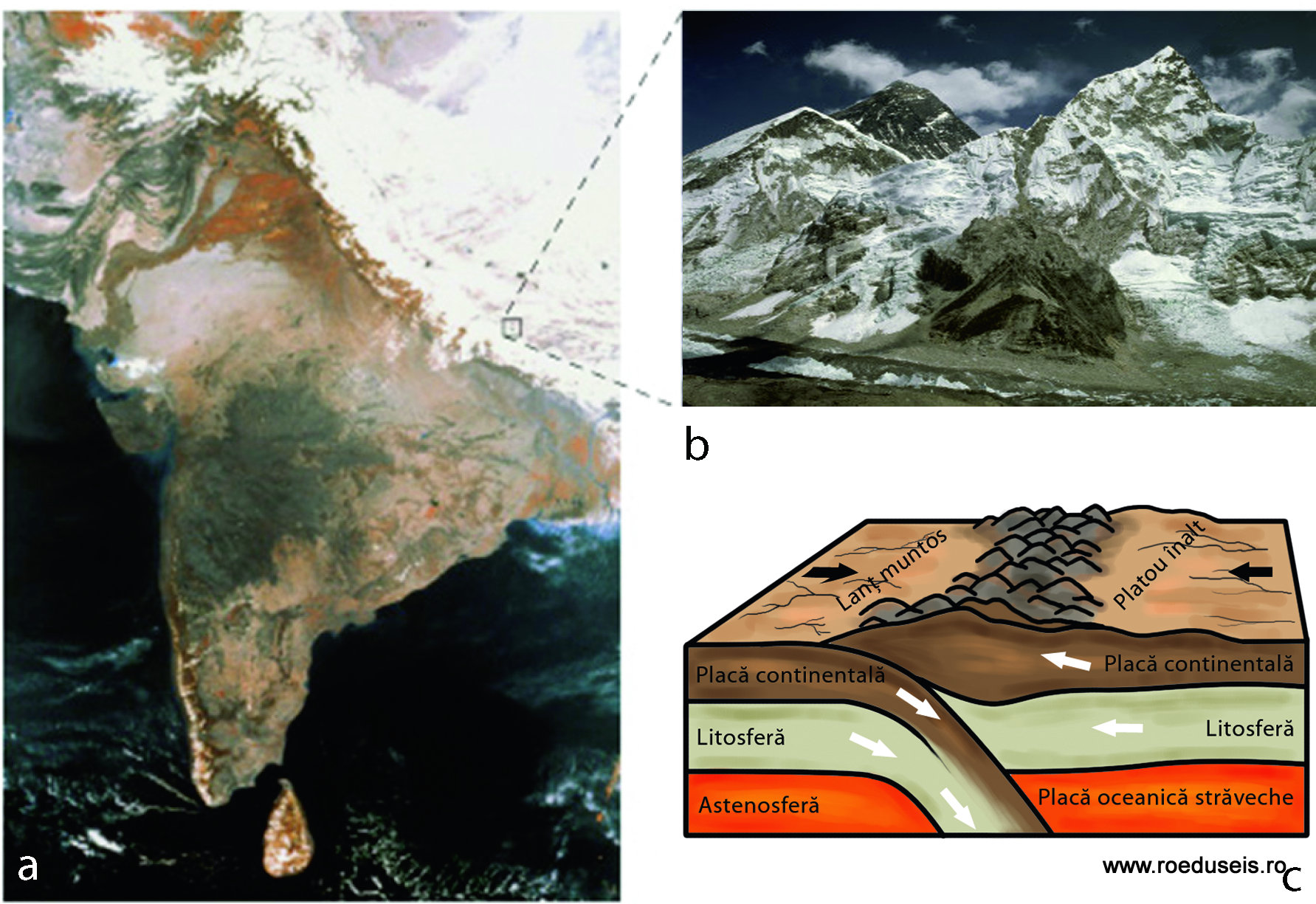
The convergence between two continental plateaus (or continental portions of the ocean plates) has the effect of forming continental mountain chains.
a. Convergence between two continental plates
b. The subcontinent of India, an infrared satellite image, colliding with the Asian continent as it moves northward along with the entire Indian plate. The impact has led to the lifting of a huge mass of rocks that formed the Himalayan mountain chain (snow covered in the upper right corner of the image); c. Mount Everest - a result of the collision between the two continental masses (shaded crest in the background) (http://astronomy.nju.edu.cn)
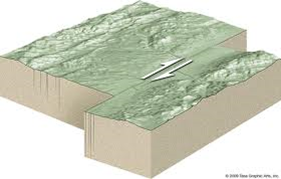
Transform boundaries - found in areas where plates merge one next to each other. The concept of transforming faults refers to those fractured areas that connect two divergent plate edges, or more rarely between two convergent plate edges. Most transformation fences are located at the bottom of the ocean. They are characterized by an important surface seismic activity, one of the most famous being the San Andreas fault (California).
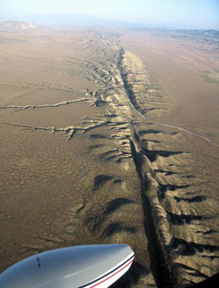
a. Boundaries of transforming plates
b. The San Andreas Fall resulting from the migration of the Pacific plate to the North American plate. It has a length of 1300 km and a width of tens of kilometers, crossing 2/3 of California's territory. (http://epod.usra.edu/blog/2006/11/elkhorn-scarp-along-san-andreas-fault.html)
Intraplate earthquakes are earthquakes that do not occur at the edges of the tectonic plates. Studying these types of earthquakes in different areas of the world, seismologists have come to the conclusion that most of them are produced by inverse failure, a process due to the compressive forces to which the rocks are subjected. It seems that the movement of the tectonic plates induces compression effects also on the unstated rocks near the edges of the plates. Intraplaced earthquakes are not as common as those produced at the edge of the tectonic plates, but can even produce major earthquakes (magnitude> 7.0). And in Romania we have such earthquakes in most of the seismic areas, except for the Vrancea area.
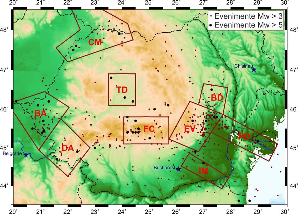
THE SEISMICITY OF ROMANIA
Seismogenic areas are defined as areas with grouped seismicity, within which seismic activity and the stress field are considered to be relatively uniform. The identification of the long-term characteristics of the earthquake generation process in each seismic area is of major importance for the estimation of seismic hazard.
On the territory of Romania, the seismogenic zone with the highest destructive potential is located in the subcrustal lithosphere, at the curvature of the Eastern Carpathians - Vrancea region.
In addition, there are several areas of seismic seismic sources of local significance: East - Vrancea, Fagaras - Campulung, Danubiana, Banat, Crisana - Maramures, Barlad depression, Predobrogeana depression, Intramoesica fault, Transylvanian depression (Radulian et al., 2000).
Fundamental seismicity - crust events with magnitude Mw < 5.0 - are sporadically observed, especially in northern Oltenia, Hateg depression, the eastern part of the Romanian Plain, the Moldavian Platform, the Oriental Carpathian Orogen.
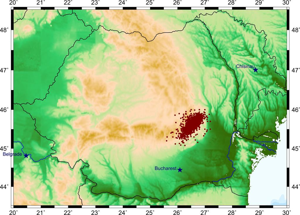
Subcrustal seismicity (depth > 60 km) (ROMPLUS catalog, Oncescu et al., 1999, updated).
Seismicity of normal depth (h < 60 km) (ROMPLUS catalog, Oncescu et al., 1999, updated). Seismogenic zones - after Radulian et al. (2000) and Ardeleanu et al. (2005).
Vrancea Subcrust Area (VR)
The Vrancea region is a complex seismic zone of continental convergence, located at the contact of 3 tectonic units: East - European plaque, Intra - Alpina and Moesica sublayers (Constantinescu et al., 1976).
The most powerful seismic activity on the Romanian territory focuses on intermediate depths (60-200 km), in a colder lithospheric body, in gravitational descent, oriented almost vertically. High activity has been observed in two areas of depth - between 80 and 100 km, and between 120 and 160 km respectively. The strong earthquakes of the twentieth century occurred in both segments: earthquakes in 1977 (Mw 7.4) and 1990 (Mw 6.9) in the upper segment, and events in 1940 (Mw 7.7) and 1986 (Mw 7.1) in the lower segments.
The rate of producing strong earthquakes - between one and six magnitude events of magnitude Mw> 7.0 per century - in an extremely limited focal volume implies a high level of relative / specific deformation rate (~ 3.5x10⁻⁷ an-1). The tectonic process at depth appears to be largely decoupled from the tectonic into the crust.
Regarding the focal mechanism of Vrancene earthquakes of intermediate depth, the inverse fallacy - with the almost vertical vertex of the extensions (T) and the quasi-horizontal compression axis (P) - characterizes all major events (Mw> 6) and also over 90 % of the events studied, regardless of their magnitude (Enescu, 1980; Oncescu and Trifu, 1987; Enescu and Zugravescu, 1990; Radulian et al., 2000). In relation to the orientation of the fault plans, two typical solutions were highlighted: (I) NE - SV inclined towards NV, and P axis perpendicular to the Carpathian Arch; and (ii) the targeted blueprint of approx. NV - SE, and the P axis parallel to the mountain arch. Available data - both macroseismic and instrumental - indicate type (I) solutions for all earthquakes with Mw > 7.
Normal or lateral / directional slipping mechanisms were rarely observed for events located predominantly at the upper and lower edge of the seismogenic volume (Radulian et al., 2000).
The tension regime in the Vrancea subcrust is predominantly compressive.
East-Vrancea Area (EV)
The superficial seismicity in the Vrancea region diffuses diffuse to the east towards the Carpathian Arch, in a boundary bounded by the Peceneaga - Camena fault in the north, and by the Intra - Moesica fault to the south (the so - called Black Sea sub - plate). Seismicity consists of moderate earthquakes not exceeding magnitude 6. Seismic activity explosive manifestations - in the form of seismic sequences or earthquakes - are frequent in this area (eg in the Ramnicu Sarat - Focsani region, in the Vrancioaia area).
Rata momentului seismic in crusta, in zona Vrancea (~5.3x10¹⁵ Nm/an) este mult mai mica decat rata in domeniul subcrustal (~1.2x10¹⁹ Nm/an) (Radulian et al., 2000).
Diversitatea mecanismelor focale - falierea inversa, alunecarea laterala si falierea normala sunt observate in egala masura - indica un camp de tensiune complex, caracteristic tranzitiei de la regimul compresiv predominant la adancime, la regimul extensional predominant in crusta.
Fagaras-Campulung Area (FC)
The Fagaras - Campulung area is situated in the eastern part of the Southern Carpathians. It is characterized by shocks that can reach up to Mw ~ 6.5, the most severe surface earthquakes recorded in Romania. The last major earthquake occurred on January 16, 1916 (Mw = 6.4) and was followed by an important replica activity.
The epicenter distribution highlights two significant groups: one located in the western part of the area, including the strongest shocks (Mw ~ 6), the other located in the east (Sinaia region), with smaller events (Mw < 5).
The focal mechanisms are of the lateral sliding type and the normal collapse, indicating an extensional voltage field. Lateral sliding type leaks predominate, the fault planes being NV-SE oriented (Enescu et al., 1996).
Danubian Area (DA)
The Danubian seismogenic zone represents the western extremity, adjacent to the Danube River, of the Orogenic Unit of the Southern Carpathians.
Rata activitatii seismice este relativ ridicata, in special la granita cu Serbia si dincolo de aceasta, peste Dunare. Magnitudinea observata nu depaseste valoarea de 5.6.
Few available focal mechanism solutions indicate normal faults, T-axis approx. N-S, in accordance with the extensional voltage regime of the Meridional Carpathians (Oncescu et al., 1988; Radulian et al., 2000).
Banat Area (BA)
The contact between the Pannonian Depression and the Carpathian Orgen lies entirely along the western border of Romania.
The distribution of seismicity indicates the existence of two relatively distinct active areas: Banat to the south and Crisana-Maramures to the north, although tectonic or geostrategic differences between the two areas were not highlighted.
The seismicity of the Banat area is characterized by relatively large earthquakes with magnitude Mw > 5, but without exceeding Mw 5.6. Stronger shocks, which are usually followed by replica sequences, appear clustered over time (in windows for a few months).
In contrast to the focal mechanisms observed in the Carpathian area (with the exception of the Vrancea crust area) and in the Southern Carpathians, where inverse falcons have not been highlighted, here the inverse fallacies and side slides are predominant. They outline a horizontal horizontal compression field in the E-W direction, in accordance with an approximately radial model of the Panonic Basin Extension (Grunthal and Stromeyer, 1992), involving E-W compression in the east of the basin in the intra-Carpathian region.
Crisana-Maramures Area (CM)
Historical earthquake catalogs report the production of magnitude events larger than 6 in Crisana-Maramures (ROMPLUS catalog, Oncescu et al., 1999 - 1 event, Shebalin et al., 1998 - 2 events in the first half of the 19th century). Based on historical information, more earthquakes with destructive effects are also reported, with magnitude over 5. In the instrumental period (starting with the 20th century), a single event of magnitude close to 5 was located in the area.
Barlad Area (BD)
Barlad Depression is a substratum depression situated in NE from the Vrancea region, in the Scitica Platform, and represents the extension of the Predobrogene Depression to the NW. The observed earthquakes are of moderate size - do not exceed Mw = 5.6.
Available fault plan solutions indicate a predominant extensional stress regime. The normal fallacy is probably linked to stepping fallacies, as evidenced by the Depression (Mutihac and Ionesi, 1974).
Predanubian Area (BD)
The seismogenic area belongs to the southern border of the Predanubian Depression, following the alignment of the Sf. Gheorghe's fault.
In general, the seismicity and the characteristics of the focal mechanisms are similar to those highlighted for the Barlad depression: moderate seismic activity (Mw <= 5.3) - mainly grouped along the Sfantu Gheorghe fault and extension of the deformation field. The similarity can be attributed to the affiliation of the two areas to the same tectonic unit - the Scitical Platform.
Intramoesic Area (IM)
The Intramoesic fault crosses the Moesic Platform in SE-NW direction, separating two distinct sectors with different constitution and structure of the foundation. Although it is a deeply defined deep fault, reaching the base of the lithosphere (Enescu, 1992) and extending to the southeast to the Anatolian False region (Sandulescu, 1984), the associated seismic activity is weak and sporadic (only two magnitude events than 5, both reported during the instrumental period). The depth of the outbreaks (when it can be constrained) has relatively high values (h ~ 35 km), suggesting an active process in the inferior crust or in the upper mantle.
The very few focal mechanism solutions available for this area are all consistent with the extensional regime observed in the Carpathian area (with the exception of the Vrancea crust region).
Depression of Transylvania (TD)
This seismogenic area is defined only on the basis of historical information.
Seismic activity is almost missing today. However, more earthquakes with magnitude over 5 (two events with Mw> 5.5) were reported on historical documents, with significant destructive effects being recorded in Transylvania (ROMPLUS catalog, Oncescu et al., 1999).
BIBLIOGRAPHY
Ardeleanu L., Leydecker G., Bonjer K. P., Busche H., Kaiser D., Schmitt T., 2005. Probabilistic seismic hazard map for Romania as a basis for a new building code, Nat. Haz. Earth Syst. Sci., 5, 679-684.
Constantinescu L., Constantinescu P., Cornea I. and Lazarescu V., 1976. Recent seismic information on the Lithosphere in Romania, Rev. Roum. Geol., Geophys., Geogr., Ser Geophys., 20, 33-40.
Enescu D., 1980. Contributions to the knowledge of the focal mechanism of the Vrancea strong earthquake of March 4, 1977, Rev. Roum. Geol., Geophys., Geogr., Ser Geophys., 24, 3-18.
Enescu D., 1992. Lithosphere structure in Romania. I. Lithosphere thickness and average velocities of seismic waves P and S. Compression with other geophysical data, Rev. Roum. Phys., 37, 623-639.
Enescu D. and Zugravescu D., 1990. Geodynamic considerations regarding the Eastern Carpathians Arc Bend, based on studies on Vrancea earthquakes, Rev. Roum. Geophysique, 34, 17-34.
Enescu D., Popescu E. and Radulian M., 1996. Source characteristics of the Sinaia (Romania) sequence of May-June 1993, Tectonophysics, 261, 39-49.
Grunthal G. and Stromeyer D., 1992. The recent crustal stress field in Central Europe: trajectories and finite element modeling, J. Geophys. Res., 97, 11805-11820.
Mutihac V. and Ionesi L., Geology of Romania (in Romanian) (Technical Press, Bucharest 1974).
Oncescu M. C. and Trifu C.-I., 1987. Depth variation of the moment tensor principal axes in Vrancea (Romania) seismic region, Ann. Geophysicae, 5B, 149-154.
Oncescu M. C., Ardeleanu L. and Popescu E., 1988. The state of stress under the Meridional Carpathians, Proc. of XXIst Gen. Ass. of ESC, Sofia, 1988, 149-154.
Oncescu M. C., Marza V. I., Rizescu M. and Popa M., The Romanian earthquake catalogue between 984-1996. In Vrancea Earthquakes: Tectonics, Hazard and Risk Mitigation (eds. Wenzel, F., Lungu, D., and Novak, O.) (Kluwer Academic Publishers 1999), pp. 43-49.
Radulian M., Mandrescu M.N., Panza G.F., Popescu E. and Utale A., 2000. Characterization of seismogenic zones of Romania, Pure Appl. Geophys., 157, 57-77.
Sandulescu M., Geotectonics of Romania (in Romanian) (Technical Press, Bucharest 1984).
Shebalin N. V., Leydecker, G., Mokrushina N., Tatevossian R., Erteleva O. and Vassilev V., Earthquake Catalogue for Central and Southeastern Europe, European Commission, Report No. ETNU CT93-0087, Brussels, 1998, http://www.bgr.de/quakecat.